Best & Most Beautiful
ISLANDS IN THE GULF OF THAILAND

Best & Most Beautiful
ISLANDS IN THE ANDAMAN

Thai Elephant
THE SYMBOL OF THAILAND


Best kid’s amusement park in Bangkok.

Si Satchanalai Historical Park
Designated as World Heritage Site Number 574 on 12 December 1991 by UNESCO, the ancient city of Sukhothai, along with its former vassal towns of Si Satchanalai and Kamphaeng Phet, is considered the cradle of Thai civilization.
To appreciate the once flourishing civilization, Thaiways would like to present the remains of this first kingdom of Siam, which include masterpieces of the earliest Thai architecture, sculptures, and other art objects. After introducing the historical park of Sukhothai in the previous issue, we are going to present the historical park of one of its important vassal towns, Si Satchanalai in this issue. The other, Kamphaeng Phet, will be dealt with in the ensuing issue.
Si Satchanalai Historical Park is located on the bank of the Yom River at Tambon Muang Kao, Si Satchanalai county, only 55 km. from the town of Sukhothai. The ancient town, formerly call "Muang Chaliang", was named "Si Satchanalai" during the Phra Ruang Dynasty when a new administrative centre was established to replace Chaliang. This ancient town occupied more than 320 hectares (800 acres) of land. Of this, the 91-hectare (288 acres) area within the old laterite ramparts and the city moat is the focus of sightseeing in the historical park and can be covered on a day trip from Sukhothai.
According to early stone inscriptions, local legends, and historic chronicles, Si Satchanalai was exclusively governed by the crown prince of the Sukhothai Kingdom. Phaya Li Thai (1347-1369 AD), known as a great ruler and scholar, was also the crown prince ruling Si Satchanalai before ascending the throne at Sukhothai.
There is evidence indicating that he wrote a book called "Trai Phum Phra Ruang," the book of life and former lives according to Buddhist concepts, while he ruled Si Satchanalai. During his reign, many temples were built and restored.
After King Li Thai passed away (around 1370-1371 AD), the Sukhothai Kingdom fell under the rule of the Suwannaphum Dynasty of Ayutthaya.
Si Satchanalai, called Sawankhalok by Ayutthaya, still maintained its status as an important town, governed only by a member of the former Sukhothai Royal Family. However, when King Borom Trailokanat (1448-1488 AD)governed Ayutthaya, the status of Si Satchanalai changed to that of secondary outpost.
Si Satchanalai, or Sawankhalok, was an important producer of glazed ceramics called Sangkhalok wares which were exported throughout Asian countries. Si Satchanalai's riverside site was crucial to the development of its ceramic industry.
Located at Ban Ko Noi, about 5 km. north of the historical park is the Celadon Kiln Site Study and Conservation Centre which contains a display of kilns, artifacts and excavated ceramics. Over 500 kilns have been excavated so far in the area of Sawankhalok town and there is evidence of the ceramics being shipped to as far as China, Japan, Malaysia, the Philippines and Indonesia. The Centre is open daily during 09.00-12.00 and 13.00-16.00 hours.
Among the remains of the 19 monuments inside the city wall, highlights are the first three monuments from the entrance, Wat Chang Lom, Wat Chedi Chet Thaew and Wat Nang Phaya.
Wat Chang Lom, the compound to the right of the entrance is distinctly Sri Langkan in style, with a characteristic stupa and 39 laterite elephant buttresses. The elephants at Wat Chang Lom are quite different from those found at other temples.
They represent standing elephants and are taller than life-size ones. Some scholars believe it was the temple mentioned in the Stone Inscription No. 1 as the place where Pho Khun Ramkhamhaeng had Buddha relics unearthed in order to pay homage to them before reburying them and building a chedi with a boundary wall over the relics in the middle of Si Satchanalai town.
Wat Chedi Chet Thaew is located opposite Wat Chang Lom to the south. The most important constructions at this temple are the main chedi with lotus bud-shaped top and 33 subordinate chedis believed to contain the remains of the royal family. The chedis are adorned with Buddha images and other stucco decorative images reflecting various art styles, including Sri Langkan, Pagan and Srivijaya.
Wat Nang Phaya, southeast to Wat Chedi Chet Thaew, is known for the exterior of the vihara made of laterite blocks, which was decorated with highly elaborate stucco, in the art style of the early Ayutthaya period. The main chedi in the Sri Langkan style, another focus of this temple, is supported by a high base, once decorated with sculptures of elephants similar to those at Wat Chang Lom.
Besides these monuments within the city wall, there are many sites that are worth visiting. One of those located to the southeast of Si Satchanalai town is Wat Phra Si Rattana Mahathat Chaliang. This large historic temple complex is one of the most impressive sites in the area. The decorative stucco bearing the Bayon art style of ancient Khmer found at the main entrance of the temple as well as archeological evidence excavated here points out clearly that this temple was originally founded before the Sukhothai period. Its main shrine was built from blocks of laterites which were later covered with lime plaster and red paint. Its architectural characteristics as seen in the present indicate that it could date back to the Ayutthaya period though some evidence suggests that the shrine might have been built to cover an earlier structure.
Si Satchanalai Historical Park is open daily from 08.00-17.00 hours and admission is 40 Baht. Bicycles are provided for rent at 30 Baht a day, and elephant rides around the park are available at 100 Baht per person per 30 minutes. Tram service is also available in the historical park.
For the correct pronunciation of romanized Thai words, see Romanization System of the Thai Language.

Sukhothai Historical Park
Sukhothai Historical Park
Sukhothai Historical Park
 Sukhothai Historical Park
Sukhothai Historical Park
Sukhothai Historical Park
 Sukhothai Historical Park
Sukhothai Historical Park
Sukhothai Historical Park
 Sukhothai Historical Park
Sukhothai Historical Park
Sukhothai Historical Park
 Sukhothai Historical Park
Sukhothai Historical Park
Sukhothai Historical Park
 Sukhothai Historical Park
Sukhothai Historical Park
Sukhothai Historical Park
Designated as World Heritage Site Number 574 on 12 December 1991 by UNESCO, the ancient city of Sukhothai, along with its former vassal towns of Si Satchanalai and Kamphaeng Phet, is considered the cradle of Thai civilization.
To appreciate the once flourishing civilization, Thaiways would like to present the remains of this first kingdom of Siam, which include masterpieces of the earliest Thai architecture, sculptures, and other art objects. This issue covers only Sukhothai Historical Park. The historical parks of the two vassal towns, Si Satchanalai and Kamphaeng Phet, will be dealt with in the ensuing issues.
Sukhothai Historical Park is located in Sukhothai province, about 427 km north of Bangkok. Sukhothai was the capital of the first kingdom of Siam, flourishing between the mid 13th and mid 14th century AD. The kingdom of Sukhothai held a vast territory extending across the Moei, lower Yom, Ping, Nan, and upper Pa Sak river valleys. The area lays between two other kingdoms, Pagan in the west and Khmer in the east.
By the 11th century, Mon and Khmer peoples had occupied the Yom valley but early in the 13th century, two local chieftains, Pho Khun Pha Muang and Pho Khun Bang Klang Hao, joined forces to drive out the Khmers from the area.
Thus began the 'golden age' of the Sukhothai Kingdom. Granted the sword of Victory and the title of Si Indrapatindraditya by his comrade, Pho Khun Pha Muang, Pho Khun Bang Klang Hao became the ruler of Sukhothai and the founder of the Sukhothai (Phra Ruang) Dynasty. As time passed, Sukhothai was gradually subsumed by the growing might of the Ayutthaya kingdom from the mid 14th to the mid 15th centuries AD. when it was annexed by the latter.
The most well-known and revered king of the Sukhothai period was Pho Khun Ramkamhaeng the Great (about 1239-1298 AD). During his reign, which began around 1275 AD, Sukhothai reached the zenith of its influence. The frontiers of the kingdom were extended to embrace much of modern Thailand and local chieftains from as far away as Laos and the Malay Peninsular paid tribute to the Sukhothai King.
According to a stone inscription, Pho Khun Ramkhamhaeng was a model king who acted as both temporal and spiritual leader of the kingdom. During his reign, the kingdom was peaceful under one religion, Theravada Buddhism, and people were content and happy. It is said that the ruler did not require his people to pay tax and they could trade in anything they wanted. In addition, Pho Khun Ramkamhaeng is credited with the creation of the first Thai alphabet.
The reverence with which the Thai people still regard Pho Khun Ramkamhaeng can be seen at a modern shrine just inside the entrance to Sukhothai Historical Park. Here, a massive statue of the royal hero, holding a book in his right hand with his sword lying to his left, gazes down on his modern-day admirers, as they present their offerings of flowers and food and pray to his spirit for good fortune.
The first capital of Thai kingdom, Sukhothai, was firstly rediscovered by King Rama IV (1851-1868), or better known to Westerners as King Mongkut, when he was a wandering Buddhist priest. Before that, nobody realized that there was anything left from the city which was once the nerve centre of a rich and powerful kingdom.
King Mongkut made the trip with a large group of followers in 1833. After breaking through the thick jungle woven with creepers and vines, he found the first stone inscription of Sukhothai beside Wat Mahathat in the centre of the town. It was taken back to Bangkok together with a stone seat known as Manangkhasila throne. The inscription was written in Thai alphabet created by Pho Khun Ramkhamhaeng himself. Now the inscription is kept in the National Museum and the stone throne in Vihara Yot within the compound of the Temple of the Emerald Buddha, both in Bangkok. More such stone inscriptions were discovered later, shedding more light on the condition of the first Thai kingdom.
Later in 1908, Prince Vajiravudh (later King Rama VI) led a team of explorers on a trip to the ancient capital by the old road from Kamphaeng Phet. The road was in a poor state of disrepair and partly covered with grass. With much difficulty the party succeeded in reaching the site. They surveyed the area and drew maps in detail but no digging was made. So Sukhothai was again lost in the jungle soon afterwards.
Then came the first large-scale expedition made by a group of students and lecturers from Silapakorn University of Bangkok in 1952. By that time, the place was sparsely populated with a few houses scattered here and there, and there were still tigers, leopards, bears and other wild beasts roaming the area. When the students went out to survey, they were warned by local residents to go anywhere in groups and to come back before dark to avoid danger.
The forest in and around Sukhothai could be called virgin, since it had remained untouched by human beings for centuries. All temples were hidden in lush growth of trees and vines, which had to be cleared before one could reach the inside. The jungle was so dense that one would easily lose one's way even in the heart of the ruined town in broad daylight. With unwavering determination, however, the students were able to copy down large numbers of architectural designs of the temples.
It was not until 1960 that the government started to build a road to the ancient capital which is 8 km away from the new town of Sukhothai, and to restore the old temples. As a result, the jungle was removed at long last and the place has become another important tourist spot.
Among the ancient monuments within the city wall of Sukhothai, the largest and most impressive is Wat Mahathat where King Mongkut discovered the first stone inscription. Its main chedi (stupa), vihara (assembly hall), mandapa, ordination hall (uposatha), and approximately 200 subordinate chedis, as well as some fine Buddha images are overwhelming. These stupa represent various architectural influences. Apart from the lotus bud shape, which is the definitive style of Sukhothai, there are also chedis in the earlier styles of Hariphunchai, Lanna and Sri Langka. Two impressive statues of the 12-metre-tall standing Buddha, Phra Attharot, enshrined in the mandapa on both sides of the principle chedi.
Wat Si Sawai, 350 metres south of Wat Mahathat, is also impressive, not for its size, but for the distinctiveness of its architecture. There are three massive Lop Buri style, corn-cob-shaped prangs, intricately decorated with stucco images of Garuda, Naga and other beings in Hindu Mythology. This structure indicates the Khmer-dominated style.
Wat Sa Si, northwest of Wat Mahathat, is attractive for its location. Standing in the middle of a reservoir, the ruins are reached via a bridge. Important buildings include a bell-shaped chedi, serving as historical evidence of the prevalence of Singhalese Buddhism in Sukhothai. The ordination hall in the middle of the reservoir points to a Buddhist concept of demarcating an area where monks perform religious functions by enclosing the holy precincts with water as a symbol of purity.
Altogether there are 21 structures within the city wall. Alongside these, a further 70 worthy sites lies in the immediate vicinity within a five kilometre radius.
The sites are open daily from 08.30 - 16.30 hours. They are separated into five zones (north, south, east, west, and central) and admission to each is 30 Baht, with the exception of the central zone where the admission fee is 40 Baht.
Probably, the easiest way to move around the zones is by bicycle which can be rented from the park at 20 Baht a day. However, there is a tram moving from site to site and costing 20 Baht per person.
For the correct pronunciation of romanized Thai words, see Romanization System of the Thai Language.

Pai
Mae Hong Son or the Land of Three Mists is located in the northwesternmost part of Thailand, bordering Chiang Mai in the east, Tak in the south, and the Union of Myanmar in the west and north. It has an area of 12,681 sq km and a population of 236,993 (end 2001). The climate is cool all year round. It is known as the land of three mists because it is shrouded in mist most of the time in the whole year, no matter whether it is the hot, rainy or cool season.
Until the early 19th century, the whole region was only inhabited seasonally by small numbers of Shan people from the Burmese border, who moved from place to place without permanent dwellings. Then, around 1831, in the reign of King Rama III, the King of Chiang Mai sent one of his governors named Chao Kaeo to the western jungles to catch wild elephants. It was only then that the widely scattered Shan tribesmen were organized into two villages. One of them was called Mae Rong Son, meaning the village with a stream for training elephants. The name was later changed to Mae Hong Son and became the name of the province.
The population of the province consists mainly of Shans (who call themselves Thai Yai) and Lanna (i.e. northern) Thais.
It also includes some Karens, Mountain Thais, Hmongs, Luas, Lahus and Lisus. Among these, the Padaung tribe (a branch of Karens) is most amazing, for the women of the tribe have a tradition of wearing numerous brass rings round their necks, as well as their wrists and ankles, making their necks look exceptionally long, just like some African women.
Mae Hong Son has several tourist attractions, both natural and cultural. Being mountainous, the province has many waterfalls and caves. Some interesting ones are: Mae Surin Falls National Park The waterfall is about 100 m high.
It is probably the highest waterfall of Thailand and is considered one of the most beautiful in the country. Phasua Falls, located in the Phasua Forest Park, is large and always full of water. The luxuriant mountain forests and the peaceful surroundings attract a large number of tourists to visit there every day.
Caves in the province are also worth visiting. Of these, two are prominent -- Tham Lot and Tham Pla. Tham Lot is a large cave about 20 m wide and 50 m high, full of stalagmites and stalactites. One cannot walk through the entire length of the cave (about 1 km) without a lamp because the cave is very dark inside. There was a discovery of some ancient utensils around 2,000 years ago in the cave. Tham Pla or Fish cave is so called because the stream inside the cave, which is only 2 m wide and 1.5 m deep, is full of big fishes all year round. They never go elsewhere, though there is nothing to stop them from swimming up or down the stream. And nobody dares to harm them, because people believe that they belong to the god of mountains and forests.
Thung Buatong is a place you should never miss. If you travel from Chiang Mai to Mae Hong Son by Highway 108 in the period from November to December, about one hour after passing Khunyuam county, you will be fascinated to see a sea of golden Mexican sunflowers (Tithonia Diversifolia) blooming along both sides of the road over the rolling hills for miles.
These wild flowers, called Buatong in the northern dialect, look exactly like sunflowers but are much smaller. There is a lesser Thung Buatong in Mae Sariang county, also along Highway 108.


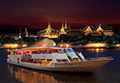
The program including 4 temples and 1 palace: Wat Arun (The Temple of Dawn), Wat Benchamabopith (The Marble Temple), Wat Trimitr (The Golden Buddha), Wat Pho (The Temple of Reclining Buddha), The Grand Palace & The Temple of the Emerald Buddha (Wat Pra Kaew).
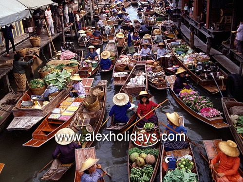
This authentic floating market is one of the most photographed places. It is located in Ratchaburi, about 100 km from Bangkok. Take a long-tail boat to the Floating Market where you will see the lifestyle of Thai people along the canal. Many vendors floating in their small rowing boats selling local food.
![]() Alex Holiday is a Bangkok-based travel agent, operating tour services and providing hotel reservations all over Thailand. We specialize in cultural, trekking, adventure and golf tours as well as other tailor-made tour packages. We can organize all kinds of travel for you. More details...
Alex Holiday is a Bangkok-based travel agent, operating tour services and providing hotel reservations all over Thailand. We specialize in cultural, trekking, adventure and golf tours as well as other tailor-made tour packages. We can organize all kinds of travel for you. More details...
Pattaya Beach is divided into the north, central and south zones. The beach offers excellent facilities for watersports enthusiasts of all kinds.

Patong is the most famous beach in Phuket. With its wide variety of activities and nightlife, it is an ideal place to relax, party and play.

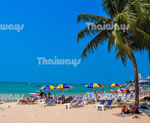
This 7-km beach is the longest and the most popular beach on the east coast of Ko Samui. It has clean white sand and clear blue water.

A popular beach destination about 3-hour drive from Bangkok. Its long sandy beach with a relaxed atmosphere is great for family holiday.